Rome and the Metro: A Story That Spans Centuries
The city of Rome is still far from meeting the efficiency standards in terms of mobility that are found in major European capitals. It lags significantly in developing a suitable local public transport network. Despite having the world’s largest historic center, Rome lacks an organized and convenient road system. The idea of creating fast connections between different areas of the city dates back to the second half of the 19th century. However, no one had yet developed such an ambitious project for the Eternal City, unlike what had already happened in other parts of Europe.
In July 1911, the Nathan administration approved a project that included building a railway to connect the commercial port and the seaside district to be developed in Ostia with Rome. This project consisted of a long surface section along the coast to Porta S. Paolo and an underground extension to Piazza Venezia, with the prospect of reaching Piazza del Popolo. “The underground penetration up to Piazza Venezia marks the beginning of a line that addresses all the serious issues of circulation and traffic, monuments, aesthetics, commerce, traditions, and modern Rome.”
The first metro system in Rome (now Line B) was designed and started in the 1930s during the fascist era. It was created to provide a rapid connection between Termini Station, the city center, and the new district known as E42, where the Universal Exhibition of 1942 was planned to be held.
The event never took place due to Italy’s entry into World War II in 1940. At the time of the interruption, some tunnels (in the section from Termini to Piramide) had already been constructed and were used as air-raid shelters. Construction resumed in 1948, coinciding with the progress of work in the former exhibition area, which partially changed its appearance, purpose (becoming a business district), and name (EUR).
The first line of the Rome Metro was inaugurated at Termini on February 9, 1955, by President of the Republic Luigi Einaudi, while regular service began the next day. The second stage of the metropolitan transport network planning began in 1959 when Law No. 1145 of December 24 allocated the first 26 billion lire to build the line. It was activated on February 16, 1980, running from Ottaviano to Cinecittà, and was extended to Anagnina in June, covering a distance of 15 kilometers. Twenty years later, between 1999 and 2000, the line was extended northwestward from Ottaviano to Battistini.
In 1990, Line B was extended from Termini to its current terminus, Rebibbia, and a new station, Marconi, was built in the existing section. In the following years, additional stations were opened: Ponte Mammolo and Quintiliani. In the fall of 2005, work began on the construction of a branch of the line on the northeastern side, known as Line B1. The first section, from Bologna to Conca d’Oro, was inaugurated in June 2012 and later extended to Jonio in April 2015.
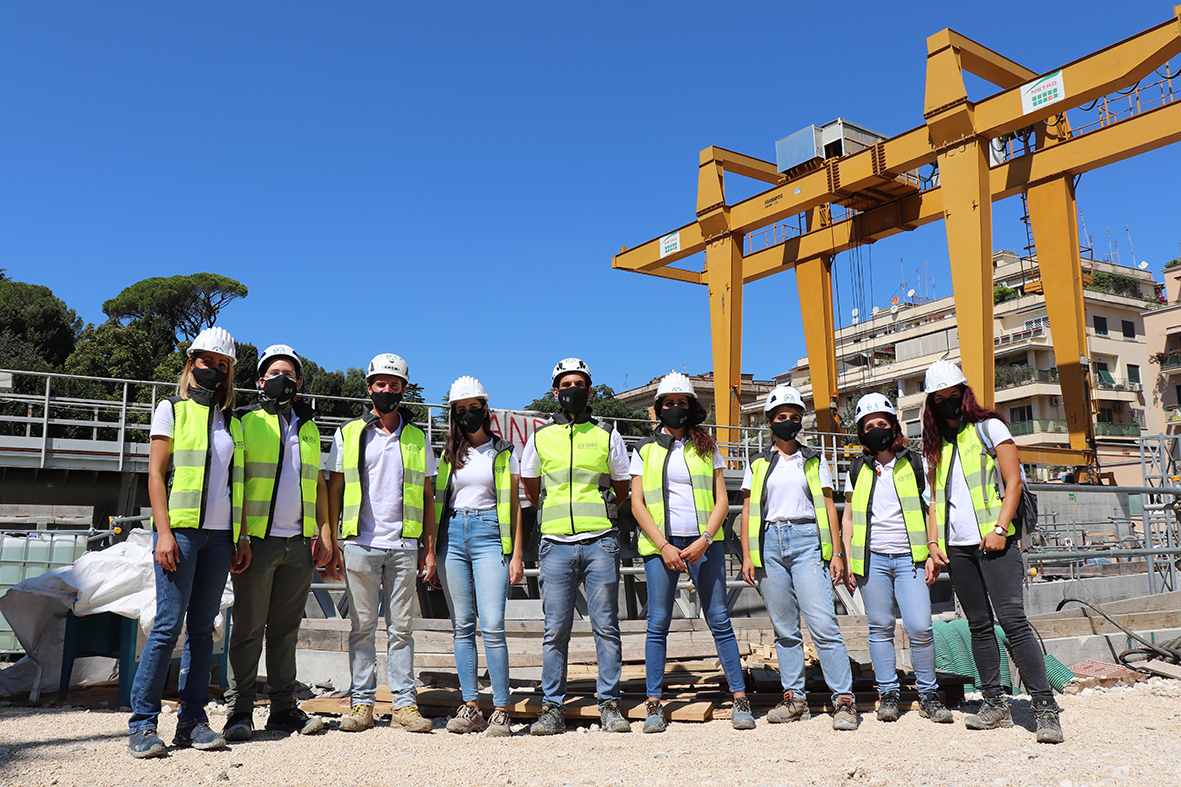
In May 2006, with the opening of archaeological survey sites, the construction of Line C effectively began, and the first construction site opened in April 2007.
The Project by Lorenzo Allievi
The first comprehensive project for a metropolitan railway network in the city of Rome dates back to 1885 and was developed by engineer Lorenzo Allievi.
A few years before Allievi, another engineer, Francesco degli Abbati, had proposed an urban route that, in the northeast area, passing beneath Villa Borghese, the Pincio, and with an underground station at Piazza di Spagna, was intended to continue towards what was then called the “Macao” district, today known as Castro Pretorio. The route was supposed to connect with the Roman Railways to the east.
“The concept of a railway artery passing through the inhabited urban area of Rome is not new, as we see implemented in the most prominent capitals. However, neither the problem was ever studied with a clear understanding of the needs it intended to satisfy, nor did it ever go beyond the stage of simple and vague preliminary projects… The new route proposed here, studied in every detail and coordinated with the Urban Plan, as well as with a future railway reorganization of the Capital, is inspired by a concrete and precise idea of the dual need that the rapidly growing development of Rome makes increasingly sensitive every day, namely:
- The need to facilitate internal urban movement;
- The need to organize and connect the railway communication system of the capital with the smaller surrounding centers.”
(Eng. L. Allievi “Metropolitana di Roma,” published in 1885 by Stabilimento Tipografico dell’Opinione)
The reference Master Plan for the project developed by Engineer Lorenzo Allievi dates back to 1883. It doesn’t contain specific indications regarding transportation, but it defines some crucial urban development elements that Allievi incorporated into his project. The Master Plan confirms the new expansion neighborhoods identified a decade earlier by the previous Plan, namely Prati Castello, Gianicolo and Trastevere, Testaccio, Aventino, and Flaminio. It highlights the need to expand and expedite the realization of public works for which Law 209/1881 made substantial funds available. The Plan identifies the location of significant military facilities (barracks on Viale delle Milizie, military hospital on Celio, barracks in Castro Pretorio), areas for the Palazzo delle Esposizioni along Via Nazionale, the scientific faculties of the University on the Viminale, the Policlinico at Porta Maggiore, and the location of the Palazzo di Giustizia in Prati.
As mentioned earlier, detailed planning for the city’s metropolitan transport network would have to wait until 1941. In that year, the Regulatory Plan for the Rome Metro was approved, developed by the Superior Office for the Metro and Suburban Railways of the Ministry of Transport under the direction of engineer Vito Perrone.
Three years earlier, construction had begun on several sections between the Pyramid of Cestius and Termini Station, which in the 1941 regulatory plan would later be called “Line B,” a designation that was retained when Line A opened (from 1955 to 1980, the line, the only one in service, was simply called the Metropolitana di Roma).
At the same time, work had commenced on a line between Termini Station and Torre Spaccata. The regulatory plan outlined an extensive metropolitan transport network, consisting of three main lines (A, B, and C) and secondary lines, covering not only the central and most urbanized area of the capital but also providing connections to the sea and the suburbs, in anticipation of the city’s future expansion.
After a stretch parallel to the Pincio embankment, it reached Piazza del Popolo, crossed Villa Borghese, thanks to a specially designed viaduct to conceal the tracks. Then, it entered Monte Parioli and continued to the banks of the Tiber River, crossing the river with a single-span bridge at Piazzale Flaminio. From there, it continued along the right bank of the Tiber to Prati di Castello (near Castel Sant’Angelo) and terminated at an interchange station with the Rome-Viterbo railway line.
The proposed metropolitan line had a total length of 8,500 meters, with an estimated cost of twelve million lire at the time. The intention of Engineer Allievi was to raise this amount from private and public investors. Due to the high frequency of trains, running every 10-15 minutes, and to avoid the annoyance of train smoke, the designer envisioned the use of Honigmann locomotives with chemical regenerators.